The North Channel...
August 23 - September 1, 2023

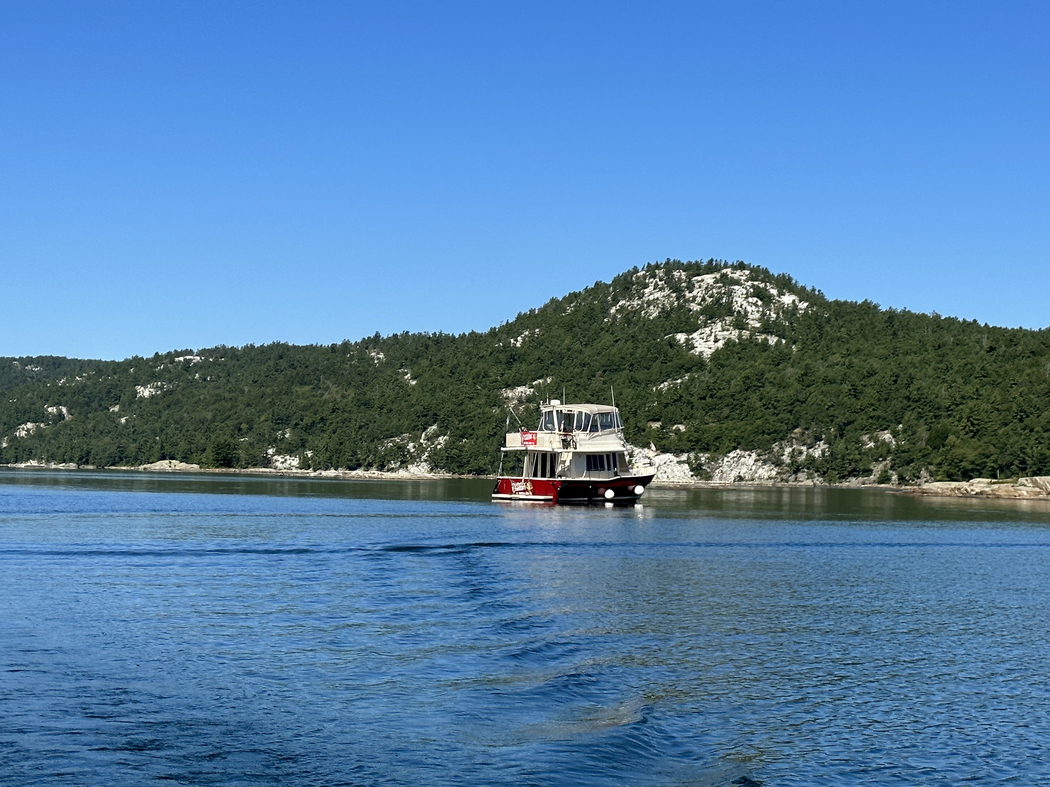
As we motored closer to the North Channel, we could see the La Cloche Mountains in the distance. La Cloche Mountains which are considered some of the oldest mountains in the world at 2.3 billion years old appear snow covered in the distance but are actually quartzite. Up close, you can appreciate the whiteness of the rock. There were nature painters throughout this area who were referred to as the Group of 7 doing landscapes of the mountains. You can appreciate the "snow" in the picture. The white color on the rocks I mentioned was quartzite. You can see the Quartzite deposits on the rocks I found hiking and could get up close.

Killarney...
This is the beginning of the North Channel. We arrived a day earlier than planned due to winds and stayed a day longer but the Killarney Mountain Lodge is a very nice place to be "stuck." There were good hikes, lighthouses, and coves we found and enjoyed. They actually had a music festival so the little town (4 blocks by 3 blocks) was quite crowded but everyone was enjoying themselves! Historically, the town was originally named Shebahonaning "safe passage" and was home to the Anishnaabek people. The area began as an outpost for fur traders then lumbering along with fishing. While fishing still exists, tourism is now the number one industry. We spoke with the nephew of Herbert of Herbert's Fish and Chips, he told us they have 10 licenses but the government is taking the licenses when people stop fishing and gives those licenses to the Indigenous people in that area. They serve pickerel, also known as walleye, which was very good. Danny and I had lunch there one day. You could see the employees in the back cutting the fish for meals and vacuum pack for people to buy for home. The other fish you will seen caught in this area is muskie, white fish, pike, and large as well as small mouth bass.


As all the towns we visit, there was a Catholic church with beautiful stone. In the early days, the house to the right was the rectory and a larger house on the left a convent. Military memorial to those killed in World War I & II and those that participated in the Korean War was in the downtown area.


Remember me mentioning the alcohol store- LCBO? This is the only one in Ontario with no front door because you enter at the back door at the dock! Of course, you can see Danny with his small purchase!

While I was walking in town, I stopped in a bakery and met Herschel. Nice guy who was a fisherman by trade from Little Current who came to the music festival. We started talking and he is starting a BBQ business in Little Current. Sounds like he has done his homework traveling through Mississippi, Alabama, Texas, Tennessee, and North Carolina. He bought his smoker from some business in Georgia. I know he has the passion for it and if I ever come back will look him up. I told him I wanted a picture for my blog and he said, great, just make sure to get my name in the picture.
The Big Dipper- the world's biggest paddle made of eastern white cedar weighing 22,000 pounds and 110.5 feet long and 17 feet wide.


Covered Portage Cove...
This cove was about 3 miles west of Killarney. Our original plans were to anchor here overnight but again the winds were prohibitive. We had a window of about 4-5 hours so we chose to dinghy over and walk up the mountain on the trail. As you enter the cove there is a rock formation called the Indian head. I hope you can see it! We took a selfie when we were on our dinghy ride to Covered Portage Cove.


One of our activities in front of Killarney Mountain Lodge was watching the boats pass by in red Adirondack chairs on the North Channel.


Baie Fine (pronounced Bay Fin)...
This area is a long channel ending in a cove called the Pool. The mountains north are called the Blue Ridge Mountains (seriously!) but they are not blue and you can see the quartzite deposit. Much of this land is part of the Killarney Provincial Park. Like others, there are walking trails to enjoy. In addition to this, there is a hike up a part of the mountain to Topaz Lake. While we anchored about 3 miles short of the pool, we rode the dinghy up to the pool to walk up to Topaz Lake. It really was beautiful and there were a number of rock ledges to jump off in the water. To me the problem was, we were told it was 63 degrees. I decided I had enough of medical emergencies and chose to watch others since I did the hike up. This area known for rock fossils and rocks of all different types made David and me interested in trying to find rock fossils. Well we tried on many beaches in this channel and maybe we have 2. BUT, I did find 5 pieces of sea glass, so not a total loss!


Just prior to the arrival to the pool and directly across from where we went ashore is the location of the home of the Ole Evinrude family. The founder of Evinrude Motors built this home. While I don't know when it was built, Ole died in 1934 so it was before then. In addition to flying the US and Canadian flag, there was a flag with Evinrude flying. Our understanding is the home is still owned by the family. As the founder of Evinrude motors, we were told the story that when he saw people with engines other than Evinrude pass by his home here in Baie Fine, he would tell them you get rid of that motor and I will give you an Evinrude to put on your boat. Word has it that many a person has pulled up old engines off the bottom of this part of the waterway. He apparently would come to the home on an 80 foot yacht and use the yacht to provide power to the home while he was there. I just can't imagine how in the world he found this place to build the house. Another interesting story about Evinrude is the company would give its employees off 2 weeks in the summer. Each employee was allowed to take an engine home for the 2 weeks to use on a boat while on vacation.

We did have to move the boat after our initial anchoring as we got caught up in a lot of weeds. So Danny got out on the pulpit removing weeds, while I drove the boat to reset the anchor.

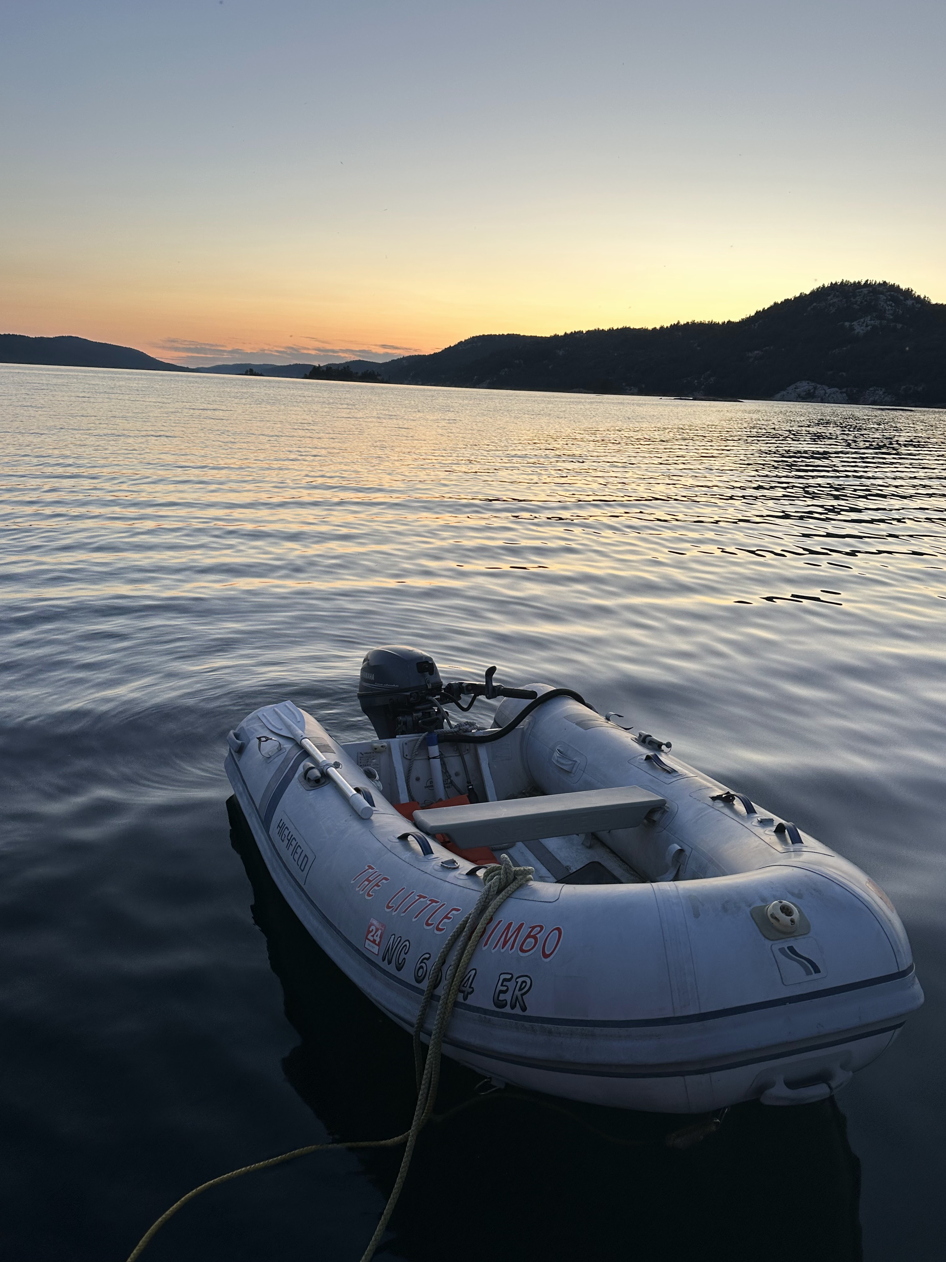
Danny and I travelled up and down the channel looking for beaches to investigate further for fossilized rocks. The water was super clear and COLD! You also will see our dinghy at rest where we went ashore at an anchorage at sunset at Baie Fine.


I saw a frog while returning to the dinghy. I can't tell you the last time I saw a frog! Also a very colorful grasshopper on the beach.


In the process of riding around in the cove where we were anchored, I noted a rock with historical significance. It was called Raber Rock. There was an Ojibwe rock painting pictograph on the rock which could sometimes be difficult to see. So I asked Danny could we just ride over to see if I could find it. I sure enough did! I could not appreciate it as much until I got back to the boat to look at my pictures. See if you can see it- it appears to be a woman.


Little Current...
Leaving Baie Fine, the plan was to go southwest towards Little Current which is on Manitoulin Island. There are 3 bays where you can stay on Manitoulin Island and Little Current is said to be the biggest one. Well the town is 2 blocks long and 3 blocks deep. Everything you need- grocery store, pharmacy, fuel, ice, coffee shop, and a couple restaurants not to mention Danny's beloved The Beer Store and LCBO! Coming into town, we passed Strawberry Island and its pretty lighthouse.

Our timing leaving the anchorage needed to take into consideration the opening of the Highway 6 swing bridge. This bridge allow residents to cross the North Channel going north. The bridge opens on the hour BUT... traffic is stopped on the hour and reopens 15 minutes later. There was information given to us that it takes 6 minutes to open and 6 minutes to close, allowing any boats to pass only 3 minutes. We got there 15 minutes earlier to make sure we were there. As it turned out the 15 minutes was correct but we don't believe it took 6 minutes for opening and closing. There were 6 boats to go through as the bridge clearance was 16 feet despite publication of 18 feet. We think because the water level was 2 feet above chart datam, this accounts for the 16 feet clearance. The bridge is over 100 years old starting as a railroad bridge and now a one lane road bridge for traffic. This area most especially has history of bad currents from 4-7 knots at the bridge making some to say, this town should be Big Current, not Little Current. The current is strictly wind driven. It is the only place in the North Channel with a current as water is funneled into a passage 100 yards wide and add wind.

Following the passing of the bridge, there is a red marker shaped like a boat to give you direction of the wind and current to help with your docking at the marina. We were lucky on the bridge and docking!

The Hudson Bay Company asked for permission to move their office from the Canadian mainland to Little Current because of a decline in trade. It was the first building considered of European structure. Before Hudson Bay could begin trade, the government rescinded the license in 1859 due to opposition from the Indians and the missionaries who lived on this land.
Once we secured our lines at the town marina, I wanted to take Danny to get ice cream as I heard 3 Cows and a Cone had great ice cream. It was good but Danny said it was not what he had in Montreal. Then it was off to Manitoulin Brewing. Danny has had some of their beers previously and he enjoyed them. Because bad weather was expected with high winds and rain, the brewery was just selling beer to take out. So he got some of his favorites and we went to the grocery store. Another neat store was Turners which has been around since the 1880's and stays open all year. Turner's claim to fame is maps and they are from all over the world and absolutely beautiful. A few doors down was Local Beanz which had great pastries not to mention chocolate desserts (5 stars in my book). Then the rain and winds came amounting to 35 MPH so there was lots of bouncing around but I was glad we were tied down and not anchored. The next morning we still had a good wind and went over to the Local Beanz for breakfast. While there, we were reminded by some Loopers that Roy was doing his Radio Show at the Anchor Inn in about 15 minutes so we decided to go. I am so glad we did. 


Kagawong...
The young man at the marina gave me a phone number to Mother's Taxi Service. I felt sorry for him as he called me from the 2nd bay down where he had to handle boats who broke lines in the high winds overnight. Like everyone else, they were short handed and did not get assistance until one of the high school kids showed up in the afternoon. Mother's Taxi agreed to pick us up early afternoon allowing David and I to go down to the beach to look for fossilized rocks which the guy at the marina suggested. The driver arrived and was quite interesting for our 30 minute ride to and from Kagawong. The town of Kagawong is named by the Indians which means where falling water throws a mist. Our driver lived on the reservation and was a member of the Obijwe tribe. We never did know his name but he told us about lots of things- the reservation(he didn't like that the kids went to school on the reservation and did not assimilate with other kids); wind farms(GE pays the reservation money for using the land); drugs(bad everywhere); corruption(the white man was crooked but some people on the reservation were crooked too). On our way to the falls, we had to pull off the road so he could buy some cigarettes where they were cheap. While he was gone, I looked at everyone and said I didn't realize what we were getting on this outing. We certainly got entertained!
There are 3 reservations on Manitoulin Island with the biggest one being around Kagawong. The interesting sites here are the Bridal Veil Falls. In addition to be on a trail, you can actually walk behind these falls to see it from the backside which was fun. So I got pictures of us both in front of and behind the Falls. The trail takes you to downtown where there is a chocolate shop called Chocolate World where they make the items on premises. It was very good and our purchases did not last long!


A couple blocks down was the St John the Evangelist Anglican Church built in 1938. It is known as the sailor's church. The pulpit is made of the remains of sunken ship from 1960 where 4 people died. Those who perished are named on a plaque on the pulpit.


This day ended with a stop at Manitoulin Brewing for an early dinner and hopes to see the Super Moon. And yes, I lucked out as Danny was asleep. The picture does not do the moon justice!

The South Benjamin Islands...


There were many Looper boats in Little Current with most people heading for the same destination, The Benjamin Islands. We had heard they were beautiful and there were multiple anchorages so enough room for everyone. Given we missed the Bustard Islands in Georgian Bay, the Benjamin Islands were a must for me. In addition, Roy had told David a place a dinghy ride away from the northern part of South Benjamin on Hook Island to look for fossils. So the four of us agreed to leave at sunrise to make the most of the day. The ride was great and South Benjamin was beautiful. We arrived at South Benjamin-3 as the charts call it for anchoring. There was only a sailboat there. By the end of the day, there were 16 boats total. We hopped in the dinghy and went over to Hook Island. I was not impressed with the fossils but did find sea glass. The east side where we were on was very rocky and I walked from the south to the north end of the island. The winds were really thrashing the west side so we stayed put. As we got ready to leave, Roxanne and David's dog, Goose, was nowhere to be found. The island was heavily wooded which made things more difficult. Roxanne and I walked in opposite directions on the east side. Danny and David rode the 2 dinghies in opposite directions to cover the perimeter of the island. We were all screaming Goose without response. As Danny and David approached the beach about an hour later and no one getting any response, Goose popped out of the woods as though what was the big deal.
We returned to South Benjamin, riding around the island to look at the different rock formations and walking on rock paths. Most of the rocks here are pink granite. We did have some problems getting off the dinghy due to the slippery nature of the granite. I actually lost my footing and got drenched as you will see my clothes on the boat rail drying in the sun! Danny almost lost his footing but escaped pulling himself back in the dinghy. I was able to get these from high up on the rocks.


The rock formation that looks sloped is actually called the ski slope. The group of boats in the cove had cocktails (we actually called it rocktails here) and sang Happy Birthday to one of the women doing the Loop. We had 2 boats from Montreal where one of the women had a birthday so we sung in English and French.
Tonight, we had to make the decision that rather than going further north which we had hoped for, we would start heading south to the western edge of Manitoulin Island to Meldrum Bay. This would leave us 44 miles short of the United States in Detour Village, Michigan for the following day of travel.

The weather and wind forecast we heard with Roy on Wednesday morning didn't appear to be happening as we left and this went into Saturday. Within 2 hours of leaving the anchorage and reviewing Windfinder and Windy, Danny and I could see the winds picking up at 5pm and throughout the entire next day. I started looking at calculations at 6 different locations on the map, calling marinas, and discussing the information with Roxanne and David, we decided to bite the bullet and travel the 82 miles to DeTour Village. While this was 9 hours, we knew once we got there we would be good for 2 days and get us closer to Mackinac Island where we had reservations in a few days. We made the right call and travelled closer to the northern edge of Drummond Island to keep the wind effect down. One of the significant things we noticed in the Georgian Bay and became more significant in the North Channel was the inability to get rid of your trash. These places have no place to get rid of their own trash and have to pay to have it sent off their islands. Some would charge us $10 a bag. Pumpouts will get rid of your "black" water which is water from flushing your toilet. This is also very expensive and difficult to find in these areas because again they have nowhere to process the waste. "Gray" water can be pumped overboard and is no problem. This water is what you use in the sink and shower. We also noticed there were many aluminum boats up on these waters. I never asked anyone about aluminum versus fiberglass and what made it better versus was it just a cost savings.
We enjoyed the North Channel and its peaceful surroundings. So many more places to explore... some day hopefully.
Locks 133
TOTAL MILES TRAVELLED 4657.90 miles
TOTAL DAYS 292
TRAVEL DAYS 109

Comments
Post a Comment