The Mighty Mississippi...
October 11 - 18, 2023


Danny on the banks of the Mississippi River from both the north and south.
The Mississippi River runs 2340 miles from Minneapolis, Minnesota to the Gulf of Mexico. The river starts in Lake Ithaca, Minnesota where you can walk across stones. The Ojibway people named the river meaning big river. From a navigation standpoint, it is broke up into the upper Mississippi (Minnesota to Cairo, Illinois) and lower (Cairo, Illinois to New Orleans, Louisiana ). We will travel the Mississippi until we get to Cairo and turn on to the Ohio River. While the Mississippi River has flooded before, the worst being 1993, the river is exceptionally low this year. Last year was low and this year is worse. According to the data accumulated and released October 16th, the river is 11.85 feet below its normal depth. This has created problems for barges going up and coming down with commerce not to mention any recreational use for room to travel the waterway. I was trying to take pictures when I saw great swarths of sand but when I came across a man walking on the sand and his boat beached, I knew this best explained it! A lot of SAND exposed

In navigating the Mississippi, going down, we get a current that moves our boat much faster. Usually we travel between 8.5-9.5 miles per hour at 1800 RPM. On the Mississippi, we went 12.3- 14.1 MPH at the same RPM. While that makes me happy, there is quite a bit of debris in the water from trees to large logs, to branches. Last year on the lower rivers getting to Mobile, I remember dinging our prop and I didn't want a repeat of that event! So we had to be vigilant for debris. The Mississippi River has many important facets in the American way of life. It drains 41% of the continental United States. When examining the statistics of what gets moved up river think petroleum, chemicals, steel, coal, corn and soybeans versus items shipped down stream soybeans, steel, and corn. In moving products north starting in 1866 there was a 4 foot deep channel followed by a 6 foot channel in 1907, and a 9 foot channel in 1940. While there are deeper areas in the river which we saw, this is the minimum. The movement of products showed the energy efficiency of using the river. I have a great display from the Great River Museum which speaks for itself.

Our travel from Grafton to Alton, Illinois was a short trip, only 17 miles. This led us to the intersection of the Illinois River and Mississippi River. We saw large limestone cliffs and interesting carvings.


In this same area were painted rocks about the Piasa. According to historical records in 1673, Marquette found a painting on the cliff above of "2 water monsters." By the 1700, the pictograph was not visible. It has been created from drawings done when it was present. We had to walk about 2 miles along the highway road without a shoulder or sidewalk. Danny wanted me to make sure I stated in the blog that he went with me while cars flew by us going 70-75 miles an hour. When we were on the boat the red and blue was visible but not the definition of the face and claws.
The Mississippi River while it was wide, I was expecting it to be wider. Land along the river was a hodge podge of very old non functioning factories or well aged businesses versus just undeveloped land. As we approached Alton, we could see a functioning flour mill announcing our arrival to Alton, Illinois.

Alton was an interesting city with a number of significant events which took place in this town. At the lock is the National Great River Museum, which Danny and I enjoyed one afternoon. In addition to a number of videos to view, we also enjoyed learning more about the Mississippi River. The museum had pictures and drawings of structures used to control water flow throughout the river. I will list them for you and only talk about one. I have heard about dikes before, just didn't know there were so many types. These included notched rock dikes, multiple round point structures, W dikes, Bendway weirs, pile dikes, hard point dikes, and chevrons. The chevrons, I found most interesting. They are structures that are upside U's pointing upriver to control erosion and help to follow the river. On the middle of the upside U, sand and rock is deposited behind it to form small barely visible islands. I took a picture in the museum of a chevron from the air and then I took one from the boat which was harder to appreciate.


The Army Corp of Engineers added numerous dikes and chevrons in 2007 which have helped maintain the river. In the St Louis area, the changes saw less need to dredge and less accidents. On the upper Mississippi River, locks and dams were built in the 1930's so a deeper channel was available for boats delivering and carrying items up and down the river.
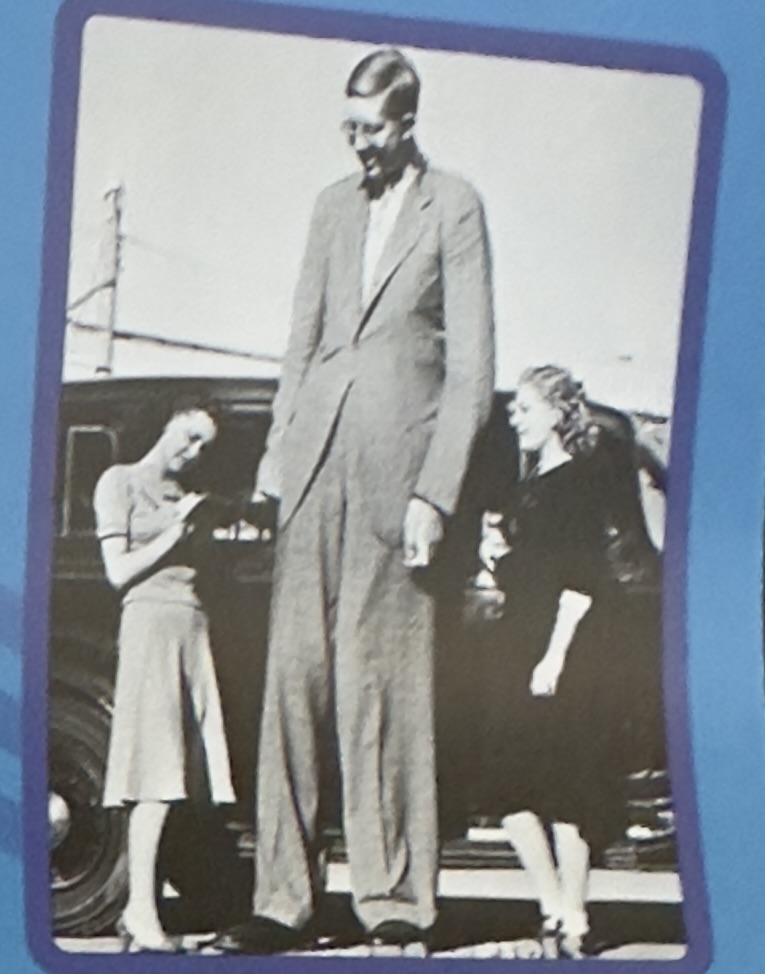
Famous people from Alton include Miles Davis, the famous jazz musician that played the trumpet and Robert Wadlow, who was known as the world's tallest man. He was born with a pituitary disorder. Wadlow's height was 8' 11.1" with a shoe size of 37AA. While I did not know his name, when I saw the picture, I remembered him being in science books during my school years.

In October 1858, the last of 8 debates was held between Stephen Douglas and Abraham Lincoln running for the Senate from Illinois. Douglas was the sitting senator and won the election but Lincoln made an impression in his presentation at the debates. Of course, 2 years later, he was elected President of the United States. Lincoln knew the town of Alton as he practiced law in this area from time to time. The bronze sculptures are on display where the debate took place.

During the Civil War, there was a Federal Military Prison in Alton. There were 266 prisoners who died of smallpox while at the prison, they were buried in the middle of the Mississippi River on what was called Smallpox Island. It is now underwater. The town people were fearful of the disease and a hospital was built for smallpox patients on another island in the river which also no longer exist. Because I left and went to Charlotte for a few days, Danny and I only had the chance to eat out a few times in Alton. We enjoyed our meal at State Street Market which had a good menu and excellent wine selection. We ate there to celebrate Bobbi's birthday. We also went to the The Bakery Beer Co, and Bluff City Grill.

As we left Alton, I saw a large statue in the distance on the Missouri side. It is called the Our Lady of the River Shrine. This was built in gratitude after a horrible flood in 1951 stopped short of destroying the town of Portage des Sioux.

The Mel Price lock just outside of Alton, Illinois handles 30% of the world's grains coming through this lock. It has 2 chambers and is the newest lock on the Mississippi River replacing 2 older ones. It was back to the lock routine where Danny drives up, I grab the line at the middle of the boat and hold the boat against the wall of the lock. This is different than the ones coming down the Illinois where you have someone hold a line in front(bow) and back (stern) of the boat.

Prior to the second lock is where the Missouri River ties into the Mississippi(picture below). This is where Lewis and Clark took the river to go west. The second lock, the Chain of Rocks is marked with a big sign- LOCK and arrow to the left. We were told a couple years ago of a sailboat didn't heed the direction and was on top of a dam for several days while dealing with their insurance. Rain came and created enough water, the whole thing went down the dam. The joke was- go LEFT!!!! Almost idiot proof for people. Otherwise, you will end up at the dam or to Iowa on the Missouri River.

When we exited that lock, within a few miles we were at the St Louis Arch. We worked out a sequence with our group so everyone could get their boat picture with the arch in the background. It was a perfect day! Danny and I have been to St Louis before and have always found it odd that the waterfront was not developed for pleasure crafts and activities. There is green space but that's about it.

Hoppie's Marina in Kimmswick, Missouri is one of the few marinas and places to purchase fuel on the Mississippi River as well stay overnight. Danny told me there was not much to see but I wanted to go by there and Danny agreed to top off with fuel. Hoppie's has been in business since 1934. Currently, the original owner's daughter and son in law own and run the business. When I saw it, I just had to shake my head- very bare bones, right on the river. The significance of Hoppie's is this is the last place to get fuel for at least 250 miles going to Kentucky and if you don't travel fast enough to cover the 84 miles to get to an anchorage you can tie up here. It is even further to get fuel if you continue to go to down the Mississippi River. We thought we might stop here, but decided to push ahead and give those behind us the opportunity to tie up.


Of course, there is more to that story too- in just a minute. We made the decision to go to Kaskaskia River lock where they have a wall to tie up overnight. Many of our friends were there and assured us there would be room for us. It was a long day-84 miles but well worth it. One of the boat, Wild Goose used his drone to get this picture. Danny did a great job getting in this space between the pole and another boat. Our friends were there to help with our lines tying up on the lock wall.

A few days ago, we were notified that one of the bridges on the Cumberland River was going to be destroyed on October 20th so they were closing that river off from Friday to Wednesday for demolition and clean up and the lock going that way would be closed as well for some issues. It makes sense to try to time them together so I understand but that leaves us with going the commercial route with another lock, more traffic and barges so we decided to push ahead to get to where we started before 6am October 20th! We are just so thankful we left Lake Michigan when we did and got this far. Because of bad winds many of the people have been up around Chicago, southern Michigan, and northern Indiana for over 10 days in the same place.
Initially the plan was to leave Kaskaskia Lock and go 110 miles to the Boston Bar at MM7.7 at the I-57 bridge. When the 7 boats got up at 5:30am, there was TOTAL fog! It was also 38 degrees and freezing. I had my clothes in front of the space heater to warm them up. We would check every 30 minutes and by 8:30 we made the move to go. The question was would we be able to do the 110 miles before dark. Because of the benefit of the current in our favor, the answer was YES! Our boat usually goes 8.5-9.5 miles per hour at 1800 RPMs but with the current, we were going 12.3 to 14.1 at the same RPMs.


As we came up to the Kaskaskia River and turned on to the Mississippi River, we saw another big ball of fog. I thought it was a neat picture. It looked like a big cotton ball once we got past it.
Another very old and rusted bridge, the Thebes Bridge built in 1905. Apparently it is the oldest surviving cantilever truss bridge in the United States. The railroad is still used today and we saw a train pass.

Continuing down the river were many miles of undeveloped land with the occasional factory on the banks and even a prison. This guy in the truck, I just knew he was going to tumble down that wall of gravel.


No problems anchoring on the side of the Mississippi River at Boston Bar. The couple next to us who were closer to the current had to reset their anchor at 11pm. My phone rang and knew it was not good. They were definitely moving so they reset the anchor and were fine until 1:30am and reset it again. We have an anchor alarm and it did not go off for us and did not move at all based on Danny's electronics! Our anchor came up clean- no mud, nothing! In 7.7 miles we would be off the Mississippi River and make our turn into the Ohio River!
Next- Ohio River, Cumberland River, and our return to Grand Rivers!
Locks 150
Bridges Openings 59
TOTAL MILES TRAVELLED 5,689.75miles
TOTAL DAYS 338
TRAVEL DAYS 136

Comments
Post a Comment